

Ireland North

Rathlin O’Birne to Killybegs, Donegal Harbour
Ireland’s northwest coast provides a wealth of rugged and wild scenery. The varied and interesting coastline on this chart stretches from Rathlin O’Birne to Donegal Harbour. Rathlin O’Birne is an island located 2km west of the Malin Beg coastline at the...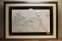
Lough Swilly to Larne B&W
This beautiful B&W chart used a nice artistic technique. An unusual feature is three inclusion of the land elevations, which show how a sailor would see the entrance to the harbour in their approach from the sea. A stunning piece for a stunning location. The...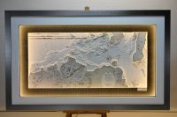
North Ireland, Bloody Foreland to Mull of Kintyre
This beautiful B&W chart features the northern Ireland coastline from Bloody Foreland to Red Bay, including Mull of Kintyre. Bloody Foreland is located in the north west of Donegal, Ireland. Bloody Foreland takes its name from the way in which the setting sun...
Lough Neagh and North Channel
Attached are photos of two versions of the same area. Both are beautiful black and white charts of Lough Neagh and North Channel. One has a surround lighting, a carbon fibre background with a black frame and one is finished with a white mount and Oak frame on a black...
Bangor Copeland Islands
This chart features the town of Bangor, Co. Down and the nearby Copeland Islands. The Copeland Islands is a group of three islands in the north Irish Sea, north of Donaghadee. The three islands are Great Copeland Island, the Lighthouse Island (which does not have a...
Carlingford Lough B&W
Carlingford Lough, inlet of the Irish Sea separating the Carlingford Peninsula of County Louth, Ireland, from the Mourne Mountains of the district of Newry and Mourne, Northern Ireland. Geographically, the lough lies about halfway between Dublin and Belfast. It is a...
Carlingford Lough
This lovely classic black and white chart features Carlingford Lough, is a glacial fjord that forms part of the border between Northern Ireland and the Republic. On its extreme interior angle it is fed by the Newry River. The Newry River and the Newry Canal link the...
Clogher Head to Carlingford & Kilkeel
This chart features Clogher head to Carlingford & Kilkeel. Clogher head is a fishing village, It is located in a natural bay on the East Coast it is bordered by the villages of Annagassan to the north and Termonfeckin to the south. It is in the townlands of...